Amateur Radio with Satellites and Space Stations
Or:
Little Houston behind the Seven Mountains


A small introduction for beginners based on my own experience

Version 25.10.2005


  Click here for Deutsche Version


Contents:

Introduction
Reception of weather satellite pictures
Getting in contact with space stations
ISS (International Space Station)
Satellite Mailboxes
Talking via satellites
Telemetry data of satellites
APRS (Automatic Position Reporting System)
Idefix, Sputniks and other mayflies
The resurrection of AO-7
Cubesats

Which equipment do I need, how do I start?
Tracking programs
Kepler Data
Transceiver and receivers
Antennas
my Shack


Introduction, and why I have written all this

Based on my own experience and the description of my ham radio station, I would like to introduce a very fascinating part of amateur radio to all interested hams: communication via satellites and space stations in your shack at home. Just a couple of years ago, anybody who claimed that his packet mailbox is moving with a speed of about 20.000 km/h at the height of 800 km, would not been taken for serious. Or anybody who claimed to have had a nice little chat with the astronaut with the MIR or ISS a few minutes ago, would have produced comments like "he is nuts".

But times have changed, communication via satellites and space stations became quite normal for many hams, and it is affordable without too much financial efforts. Most hams even don't know that they could do "space communication" with their available equipment in their present shack right at this moment. You just have to overcome your own disbelieve, for a try with space communication your present equipment is most probably is quite sufficient.

In the following chapter I would like to present several possibilities of space communication with simple amateur radio equipment and little knowledge, and explain what a beginner should try first, which useful tools are available etc. For those who have a little more place for building antennas, there are also some useful hints. If you have any other questions, feel free to drop me a mail to DK5EC@DB0MKA or

What Possibilities of space communication do I have?

I will be pleased to answer this question. I am sure that one of the following possibilities shown will be of great interest to you. Let's have a look.

Reception of weather satellite pictures

Actually, there are 2 different types of weather satellites which you can receive by simple means. The geostationary satellites are positioned "fixed" above the equator, having always the same position in relation to the earth's rotation. For Europe and Africa, the METEOSAT-7 is presently the best one, for the Americas and Pacific the GMS satellites seem to be a good choice. The elevation for your antenna differs with your own position, it is about 30 degrees in Central Europe for the METEOSAT-7. These satellites are transmitting continuously pictures of this hemisphere, that is, the half of the globe which is covered by this particular satellite. The METEOSAT-7 is positioned at 00.00 latitude and 0.00 degrees longitude, hence covering all of Europe and Africa, the eastern parts of the Americas and western parts of Asia. The pictures you receive are not in "real time", but rather a few minutes old. This is because the satellites take a picture of the whole hemisphere, transmits it to a ground station, there it is processed, retransmitted to the satellite, and finally retransmitted to the earth for the normal users. Without processing, Northern Europe or Canada would look rather distorted, because the satellite sees the very northern and southern parts of the earth in a rather flat angle, and, for the normal viewer, it would be hard to recognize anything. Below you can see 4 typical images. There are a many other formats, but the 4 pictures below give you a first impression of the possibilities. 3 of these pictures were decoded by my soundcard with freeware software WXSAT, the second picture with a hardware decoder PTC-II pro and JCComm32 Software.


The picture above shows the complete hemisphere, and was taken by the "visibility" camera. It was around noon time, otherwise some parts would have been in the sun's shadow and could not have been seen. In principle, all the satellites are producing gray shade instead of colored pictures. Most of the decoder programs turn the gray shades into nice colored tones.


The picture above shows sunny Europe and cloudy Sicily sent by the geostationary satellite METEOSAT-7. Besides using "visibility" cameras, most satellites are using also infra-red cameras which are producing other properties but look similar to those ones shown here. Others show the water content and heights of the clouds.  
The other type of weather satellites are the orbiting SATs, like the US NOAAs and the Russian METEORs. These SATs can be received by means by a home-made cross dipole. Theses satellites are orbiting the earth with a height of about 1000 km, and you can monitor the pictures for about 15 min per pass, then they will disappear again below the horizon. They return about 90 min later, but from a different direction. Since these orbiting satellites change their positions continuously, they can not be processed automatically with the continental borders as it is done with the pictures of the geostationary satellites. If the whole area is covered by clouds, you can not identify the current positions. However, this can be done with the help of a tracking program which shows you the exact position of the satellite, and from there you can assume which country is covered presently. In the picture below the Russian satellite METEOR 3-5 is showing an impressive cloud formation above the Shetland Island near Scotland.


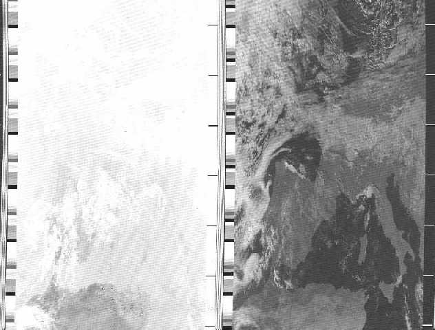
The picture below has been taken by the NOAA-14, crossing Europe. In this mode, two pictures are shown simultaneously: the left side is taken by an infra-red camera, the right one by a visibility camera. The infra-red picture has a miserable contrast, but some of the ham software allows the processing and could make it look nicer. With the newer NOAA-17 and -18, the pictures just look great in infra-red and visibility mode. When orbiting in the sun's shadow, the visibility cameras are often switched off, since nothing could be seen anyway. This is the advantage of the infra-red cameras, they don't care about sunlight. On the sides you can see some stripes and bars which actually contain some telemetry data. The ripple (moiré) in the pictures most probably derives from some local audio problems between the sound card and my receiver. I have to check that, maybe a small audio decoupling transformer will help.


Getting in Contact with Space Stations like the ISS

The contacts with the cosmonauts and astronauts of the MIR and ISS were (and are) one of the most thrilling experiences I had. Though the MIR has been sunk down to mother earth into the Pacific in the mean time, I would like to tell you a little bit more about this. I also had some contacts with the new International Space Station ISS, but personal contacts are still rather an exception. Here my experiences:

The Russian space ship MIR carried quite a bit of ham radio equipment, most of the cosmonauts and astronauts or other "passengers" were licensed radio amateurs. Unfortunately, time is short, and they rarely had time to have direct QSOs with their millions of fans at Mother Earth. However, I managed to have a couple of very interesting QSOs with them. A few years ago I contacted the German astronaut Reiter who had plenty of time because of technical problems of the Soyuz ferry which was delayed several weeks to bring him back to earth. During the last year of the MIR I had the chance for some longer chats with the board engineer Sergej Avdeyev and the French astronaut General Haignère (whose wife is also an astronaut and recently went to the ISS). But as I mentioned, this was rather an exception, something like a lottery win for a ham. Better chances were given with SSTV reception or packet radio operation. Most of the time, the digipeater and mailbox at 145.985 MHz was in operation. The mailbox operation was very difficult, because only 1 user was permitted at a time. The chances were better with the digipeater where you could try a connect with somebody (or yourself) or just send an UI frame in converse mode. If you have read a digipeated packet with your call sign (p2 R0MIR*>DK5EC [D,P]) or got a Disconnect, it was already a great feeling. And you could tell anybody that you just had a direct contact with MIR, without lying. Considering that about 1000 hams are trying to get over the digipeater at the same time, a normal QSO was not possible. The chaos was incomparably worse then at any terrestrial digipeater. Sadly I have to admit, the "right of the strongest" in power and antennas was eminent here. There was no discipline, on the other hand you have to forgive since the 1000 hams have only 10 min to try their best, and everybody wants to take his chance.
For 
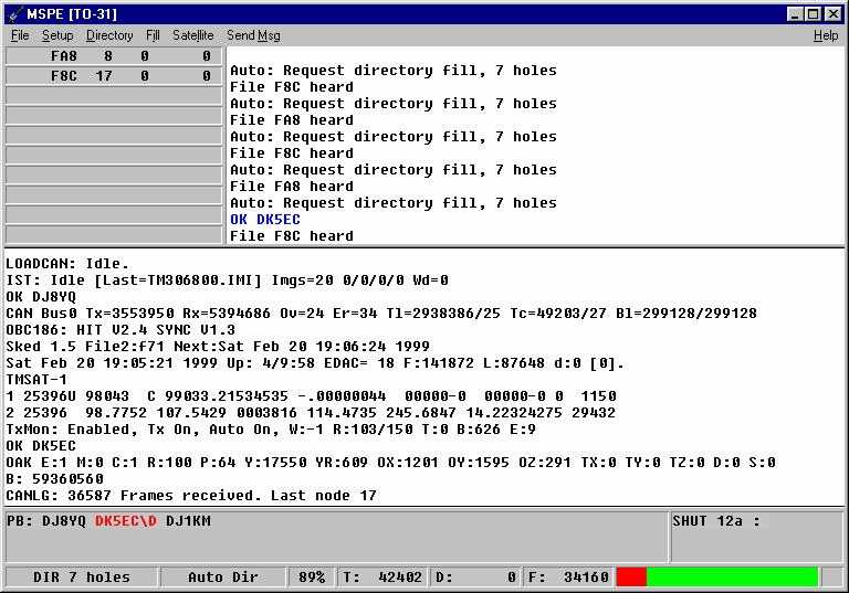
a change, I copied a typical operation of MIR digipeater and mailbox here, on the ISS it works alike. That how it looked like! The stations which were heard by the MIR tried to get into the box but were refused (DM,F). The lucky ones with the [I;0,0]: were in the mailbox. But as I said, to get a (DM,F) was better than nothing.

p2 R0MIR-1*>F5ASD (UA,F)
p2 R0MIR-1*>F5ASD

the lucky one got into the mailbox

[KPC9612P-8.1-HM$]
42047 BYTES AVAILABLE
THERE ARE 39 MESSAGES NUMBERED 7843-8114
Welcome to R0MIR-1 MIR Space Station. Please KILL your <OLD> & read messages! ENTER COMMAND: B,J,K,L,R,S, or Help >
p2 R0MIR-1*>EB2FBI
p2 R0MIR-1*>EB2FBI-1 (DM,F)

this guy is really pressing hard to get into the mailbox, but in vain

p2 R0MIR-1*>EB2FBI-2 (DM,F)
p2 R0MIR-1*>EB2FBI-3
p2 OM5LU>R0MIR*>DK5EC [C,P]

here the Slovakian station connected me via the MIR

*** CONNECTED to OM5LU via R0MIR
p2 DK5EC>R0MIR*>OM5LU (UA,F)
p2 R0MIR*>DK5EC [D,P]

here I tried to get into the mailbox, and got a friendly "Busy" back.

p2 R0MIR-1*>EB2FBI-2 (DM,F)
p2 R0MIR-1*>F5ASD [RR,P;0]
p2 R0MIR-1*>EB2FBI-2 (DM,F)
p2 R0MIR-1*>EB2FBI (DM,F)
p2 R0MIR-1*>EB2FBI-1 (DM,F)
p2 DB3WH>R0MIR*>CU3BL [C,P]
p2 R0MIR-1*>IK4SDT (DM,F)
p2 CT1FEY>R0MIR*>DB3WH [I,P;0,0]:
Connected to CT1FEY via R0MIR on 10.10.98 16:26
p2 R0MIR-1*>EB2FBI-1 (DM,F)

this guy is getting a nuisance! He is using "combat" TNC parameters

p2 R0MIR-1*>EB2FBI (DM,F)
p2 R0MIR-1*>EB2FBI-2 (DM,F)
p2 R0MIR-1*>IK1TSF (DM,F)
p2 DK5EC>R0MIR*>OM5LU [RR,P;0]

There is poll packet from me via the MIR, but no information packet

p2 R0MIR-1*>DB3WH (DM,F)
p2 R0MIR*>DK5EC [D,P]


As you can see, there was not a single decent QSO going on, but many stations got a nice Busy (DM,F). In order to get one, 10 W and 2m groundplane antenna were normally enough, some managed it with a handy. But if many high-powered stations tried their chance, than you wouldn't make it with the handy.

About every other week MIR sent some SSTV pictures. Here you can recognize some details of the spaceship as well a part of the earth. Everybody who owns a simple 2m FM radio could have received the pictures. All you need is a computer with any soundcard and a freeware SSTV program.
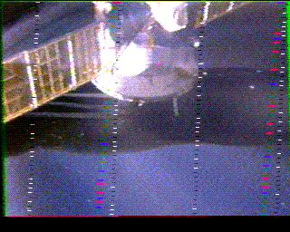
Below you can see a couple of interesting SSTV pictures received from 
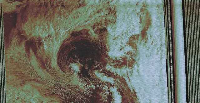
MIR. The first image was received when flying above southern Europe. Because of the clouds hardly anything could be recognized. These images are by far smaller than the ones from the weather satellites, but it 
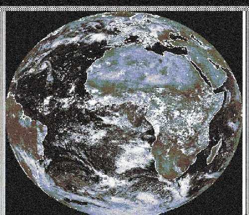
takes only about 30 s for transmission. The weather picture above from METEOSAT-7 took about 3 min.

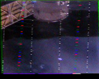
The following 2 pictures were received in the evening after sundown. Here on earth it was already dark, but the MIR 400 km above still enjoyed sunshine. The second image, taken 2 min later, shows how it is getting slowly darker. The 3rd picture, taken another 2 min later, appeared completely black because it left the sunlight going into the earth's shadow, nothing was seen, that's why I did not bother to show it here. By the way, you could watch the MIR, and now the ISS, with your bare eyes. In the northern hemisphere, it normally appears in the west or southwest. It is only visible short after dawn, that is, it is already night time here on earth, but still sunshine at the MIR. What you see is the reflection of the sun, rather than any electrical lights on board. First, it appears rather bright, and somewhere later, it disappears within a few seconds, when it is flying int the earth's shadow. This timing I met by chance when receiving these two images below.  


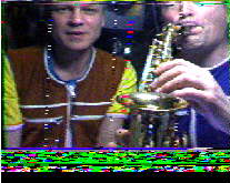
Finally, a nice picture of Sergej Avdeyev and Jean-Pierre Haignère, which I received after they played a short saxophone tune for me. I hope the FCC and other regulatory autohrities have forgiven them.


By sinking the MIR into the Pacific, the chapter MIR was not yet concluded for me. One nice Saturday last December the door bell rang, and who was standing outside? Sergej Avdeyev in reality. He had to do some business at the German Space Agency DARA near Cologne, not too far away from my home, and just wanted to see with his own eyes how somebody as a private person could manage such good communication with the MIR, just using simple ham equipment. He was telling me, that the communication between me and the MIR was often better than with Star City (Space Center near Moscow). As you all can imagine, I was pretty proud of myself, being partially better than the professionals at the space center. Of 
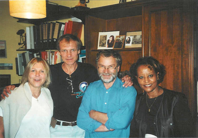
course I made some pictures with the honor guest, one of them you see below (from the left: Lieve (wife of an ESA official who accompanied Sergej to my home), Sergej, myself and last not least my wife.


ISS (International Space Station Alpha)

The crews of the US carrier space ships providing the ISS or repairing the space telescope Hubble, being in space only for a few days or weeks, often carry ham equipment, too. Mostly you can work the digipeater at 145.800/145.990 MHz, preferably APRS and UI packets in converse mode. I have managed a few short voice QSOs , but competition from earth is extreme, and the chances for a voice QSO are rare. Since they are busy building everything up, there is hardly any time for such trivial things like ham radio.  
The ISS (International Space Station Alpha) carries along now quite a number of radio amateur toys. Presently a digipeater is running, mostly used by APRS stations. The operation is identical as with the good old MIR, except the call sign of course, which is now RS0ISS. You do not need big antenna systems. It works fine, signals are strong.

The digipeater is great for APRS (Automatic Position Reporting System) contacts. UI-View is a good choice for the software. You can inform yourself about my APRS activities at 
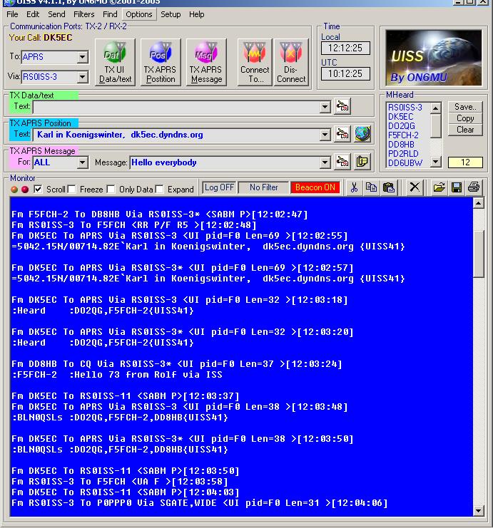
this site. But you can work the ISS with any terminal program like Hyper-Terminal and sound card or TNC. A good freeware terminal program for th ISS is UISS which you can see below, during a contact with the ISS.

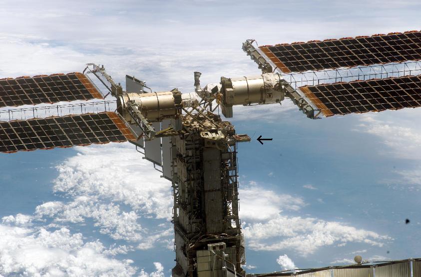
With the last Space Shutle mission, the crew took along a small suitcase named PCSAT2. During an EVA (Extra vehicular activity), the astronauts mounted it outside the ISS. PCSAT2 is completely self-reliant, has its own power supply with solar cells and antennas, independant from the ham equipment inside the ISS. Below you see the small suitcase, indicated by the arrow.

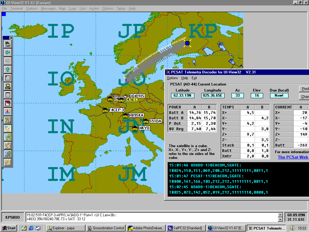
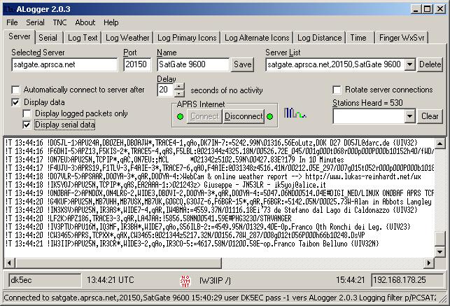
PCSAT2 may be used as a APRS digipeater. It also sends continuously telemetry data which I transfer online with the via a terrestrial APRS server to the guys of the Naval Academy whose students built the PCSAT2 and are happy to receive the data from all over the world. The program ALOGGER does the automatic transfer of the received telemetry data into he internet to the APRS sever. Below yo see ALOGGER in action.

You may also watch the live telemetry data of the ISS/PCSAT2 in a graphical view and may trace the current position with the APRS program UI-View. You can have a look at this further below when describing the APRS and AO-44 activities.


Satellite Mailboxes

A couple of satellites (GO-32, AO-51,TO-31) offer great possibilities for mailbox operation . These birds normally are operated with the uplink (from the ham station to the satellite) on 2 m and downlink on 70 cm. They fly quite a bit higher than the MIR or ISS, and transmit with less power, about 1 W only, hence the received signals are relatively low. Sometimes you hear them with a groundplane antenna, but a yagi works definitely better, and a pre-amplifier also helps a lot. The transmitting power of your station is less critical, 10 W are enough most of the time, if you are not pushed out by the "alligators". But have a try with your current 10 W 2m transceiver, you might be successful.

As I explained already above when operating the ISS, there is a often a big pile-up, considering the 100 hams who want to get into the box at the time. What does not work properly at the ISS mailbox, it works great with the mailbox satellites. Some ingenious protocol developers, also hams, have made some good thoughts with good results to overcome these pile-up problems which you see very often with terrestrial digipeaters. In principle all satellite mailboxes are using the AX.25 packet protocol, but here they use a specific channel access method to cope with these pile-up situations. To make full use out of these advantages, you need a special satellite packet terminal program. The standard program is WISP which you can download from the AMSAT page (and later make a donation). You can monitor the satellite transmissions partially with a normal terrestrial terminal program, but you will have difficulties to access the bird. The picture below shows a typical WISP terminal window.


Provided you can monitor the bird with a decent signal, you have started WISP and want to communicate with the bird, you should do the following: Nothing

That sounds strange, but it is true. the program works totally automatically. As soon as it is receiving valid signals, WISP connects your station to the bird automatically, loads down the newest directory entries, and also all files which are addressed to you. The sat confirms your connection in the upper window with "OK DK5EC" (if you were me), and puts your callsign into a queue which you can see in the lower half of the window. Then it is your turn, you download some part of the directory, the next station's turn starts, your are put at the end of the queue, and then work yourself slowly but surely to the top of the queue again. That can happen several times until the directory download is complete. In this stage, I was missing still 7 entries of the directory (see 7 holes). The same thing is happening when receiving a message destined for you. Short messages are downloaded just with one try, for longer messages you might have to queue several times. That is, the access here is regulated not by alligator power but rather by protocol intelligence. In the lower window you see DJ8YQ loading down a message, DK5EC is waiting in the queue for another directory download, and DK1JM is also waiting for another message download. It is just by chance that only three German stations are visible, normally the queue is full with callsigns from all over Europe. The 89% of the lowest window tells you about the current quality of data transfer, I have received 89 % o.k. of 100 packages. Lost packages are automatically requested for re-transmission. The lower right window shows the call sign of the station just uploading a message. Right now the uploading is shut down, it says SHUT. If it is FULL, than all uplink channels are occupied, and no other station will be permitted to transmit. Some satellites have 4 uplink channels. There is always a good chance for an upload.

Furthermore, WISP is able to control your transceiver and rotors, provided you own the interfaces. More of that topic later. I just wanted to demonstrate that the mailbox operation via satellite is quite different from the normal terrestrial operation. But with a simple terminal program you are able to monitor the signals already now with your current equipment and TNC.


Satellite Telemetry

To monitor the telemetry data of the satellites is quite a challenge and very interesting. Between the normal mailbox and digipeater signals, short data bursts are sent containing coded telemetry information. Using specific decoding software you can read these data in a clear and often well formatted way. You get information about the temperature in every little corner of the satellite, the bias of each transistor, the power output, the receiving level, the position of the solar panel, a couple of dozen voltages in the power supplies etc. As an example I copied the telemetry data of AO-16 below.

uptime is 1537/17:17:41. Time is Thu Dec 03 22:53:29 1998 PACSAT
Rx A DISC 4.475 k Rx A S meter 122.000 C +5V Rx Current 0.042 A
Rx B DISC 0.999 k Rx B S meter 161.000 C LO Monitor I 0.002 A
Rx C DISC -0.284 k Rx C S meter 127.000 C GASFET Bias I 0.003 A
Rx D DISC 0.661 k Rx D S meter 156.000 C Rx Temp 13.916 D
Rx E/F DISC 0.113 k Rx E/F S meter 148.000 C Ground REF 0.000 V
+5 V Bus [RX] 4.911 V +8.5V Bus [RX] 8.524 V +10V Bus [RX] 10.600 V
+5V Bus 4.963 V +8.5V Bus 8.482 V +10V Bus 10.448 V
+5V Bus Cur 0.275 A +8.5V Bus Cur 0.033 A Array V 10.432 V
Bat 1 V 1.263 V -X Array Cur -0.008 A +Z Array V 0.205 V
Bat 2 V 1.262 V +X Array Cur -0.024 A BCR Load Cur 0.413 A
Bat 3 V 1.308 V -Y Array Cur -0.022 A BCR Output Cur -0.007 A
Bat 4 V 1.287 V +Y Array Cur -0.018 A BCR Input Cur 0.145 A
Bat 5 V 1.267 V -Z Array Cur -0.022 A BCR Set Point 20.935 C
Bat 6 V 1.270 V +Z Array Cur -0.020 A Bat 1 Temp 6.049 D
Bat 7 V 1.303 V +Z Array Temp -5.448 D Bat 2 Temp 7.260 D
Bat 8 V 1.306 V +Y Array Temp -16.944 D Baseplt Temp 6.654 D
+2.5V VREF 2.495 V +X (RX) temp -0.607 D IR Detector 0.000 C
PSK TX RF Out -0.029 W RC PSK TX Out 0.582 W S band TX Out - 0.009 W
PSK TX HPA Tem 1.209 D RC PSK HPA Tem 2.419 D S band HPA Tem 200.000 C
RC PSK BP Temp 0.603 D
LSTAT: I P:0x14CA o:0 l:877 f:1024, d:1 st:5
BBS: Open ABCD: PB: Empty.
Array C = 0.000 Array P = 0.000 Bat Ch Cur = -0.413 Ifb = 0.145 I+10V = 0.268
TX:010B BCR:1E PWRC:59E BT: A WC:25 EDAC:74 R = Menu

AO-16 is the most reliable satellite I know. It works as normal digipeater, sending also telemetry bursts, and is perfectly suitable for APRS. However, there is rather little activity, most prably because of the necessity of a special modem for PSK modulation. Very few hams own such a modem. Too bad, becasue you can do it all with the sound card of your computer and a piece of freeware.

Some telemetry decoder programs display the telemetry data in a more elegant way, i.e. by means of graphically processed tables or curves. For the latter you will have to monitor the data a couple of minutes. Below you will see the telemetry data of AO-51 which had been processed by the freeware TlmEcho.


Furthermore, TlmEcho also stores all data as an EXCEL format which allows you to convert the data into curve diagams. Below you see the changes the chanes of the voltage levels of the solar panels during one pass.


One of the most complex amateur radio satellites is (or was) AO-40, which unfortunately ceased operaion some time ago. It delivered splendig telemetry data for a long time, as you can see below.


Voice Operation via Satellites

The analogue satellites FO-29, SO-50, AO-51 and VO-52 currently may be used for voice QSOs. There are some more, but not in operation continuously at a regular schedule. You could operate anything from 15m to 10 GHz. I can do up to 2,4 GHz, but mostly I am using 2m uplink and 70cm downlink.
The birds VO-52 and FO-29 carry SSB transponders with a bandwidth of about 100 kHz. Considering a ssb bandwith of less thean 3 kHz, many QSOs may be done simultaneously, there is plenty of space. You operate in LSB uplink on 2m and downlink 70 cm USB. It is a little bit tricky to synchronize yourself on to your partner's frequency, but after some exercise it is working just fine. First find your own downlink voice, than you know where you are. Depending on the distance, you notice a rather strong delay when receiving your own voice. With the P3 satellites like AO-10 and AO-40, the maximum distance is about 46.000 km, and it can (now could) be worked for several hours. All other birds are low-fliers, called LEOs (low earth orbit), and can only be operated for a maximum of 15 min. You hardly notice any delay there.

AO-51 and SO-50 may be operated with a normal FM transceiver, but they use only 1 fixed channel. They are very sensitive, I operated them with a simple 3 watt handy. But most of the time there are the "alligators" (big mouth, no ears) at work, and there is no chance for low power stations. Pure chaos without discipline prevails. But this is the fate of all 1-channel FM birds. You better try the FO-29 and VO-52 for peaceful QSOs.

The Russian RS satellites offer operation even in the 15m and 10 m band. They carry a lot of frequency bands and they change them from time to time. All the frequency information of the RS and all other satellites you can download from AMSAT-DL.   Information of the present status, like in/out operation, operation schedules and frequencies you also may obtain from the AMSAT-NA page.

APRS (Automatic Position Reporting System) via Satellites

APRS operation via satellites is a relatively new mode. It has been done since several years with terrestrial repeater systems as well as direct connections. Near my place, the digipeater DB0QT continuously is transmitting the position data of fixed an mobile stations. You can display the position data at a map, and you can see lots of stations which are running APRS software. A GPS hardware is not necessary if you are a fixed station at your home, you may enter the latitude and longitude of your QTH manually. APRS via ISS and PCSAT2 works really fine, sometimes the AO-44 (PCSAT) can be worked. There is quite some activity, and on the map you can recognize stations from all over Europe. A good software choice is the shareware UI-VIEW which you can download from the internet. The APRS operation via ISS/PCSAT works fine with a normal FM transceiver and a simple TNC for 1200 or 9600 bit/s. The following picture shows a typical map of UI-View monitoring a pass of AO-44. This screen shot only shows a few stations from Central Europe, but normally the map is covered with fixed and mobile stations from Sicily to the polar circle and from Ireland to Russia. you can even follow the track of satellite, right now over Finland. In the right window you see some interesting telemetry data from PCSAT.


You may operate APRS via any other digital satellite, of course. It just needs the digipeater function. In other words, the satellite does not care whether it should digipeat an APRS string or any other UI packet. The APRS packet always is generated by the ground station and not by the satellite. The only exception is when PCSAT/PCSAT2 is sending its own position. You might as well use the regular digipeater of the space station ISS for APRS which is done quite frequently. AO-16 works also very fine, it has always strong signals. Because of its PSK modulation, not many amateurs are using AO-16, and mostly I am the only user.

Resurrection of AO-7

There are miracles not only in heaven, but in space, too. On June 21, 2002, Pat Gowen, G3IOR, while scanning the 2 m band heard a CW telemetry beacon at 145.975 MHz. He could not associate his observation to any of the current operating satellites, and informed other hams about it in one of the AMSAT news forums. Some of the older guys could help out and could allocate these signals to AMSAT Oscar-7 which was launched as the second phase-II satellite on Nov. 15, 1974. It was working fine for about 6 and half years until 1981 when assumably a short circuit of the batteries occurred. Apparently the batteries turned to high impedance recently so that the solar panels are providing the energy now. It seems to be sufficient to provide the B transponder and the telemetry unit, and if the bird comes into sunlight, by coincidence the B transponder is switched on. Karl Mainzer DJ4ZC and Werner Haas DJ5KQ of AMST-DL had built this transponder at that time, as Norbert DF5DP remembers now. That was very fascinating, and I also could hear the resurrected bird, after having loaded down the kepler data and the operation frequencies. A moment later I had my first SSB QSO, sometimes with a little FM modulation, but mostly with a fantastic strong signal, operating uplink 432.150 and downlink 145.950 MHz +/- 25 kHz. I also managed to operate it via the A-transponder, uplink 145.950 and downlink 29.400 MHz. Being in an orbit of 1450 km height, AO-7 can be heard longer during one pass than most of the other SATs having a height of about 800 km only. After 21 years the band allocations have been changed, the 432 MHz section is allocated for terrestrial SSB operation. Make sure when you try to operate that bird not to interfere with other terrestrial stations.

Idefix, Sputniks and other mayflies

In addition to the a.m. satellites which are designed to be in operation for many years, you can operate some flying objects with very simple designs and little operating time. From time to time the crew of a space shuttle or Soyus carrier, while travelling to the ISS for crew exchange,just "throw" a so-called pico satellite "out of the window", more exactly, just pushing them into space by hand while working outside the space ship performing an EVA (Extra Vehicular Activity). These picos only have 1 or 2 small transmitters and a microprocessor on board and are fed just by batteries but no solar energy supply. As an example some imitations of the good old Sputnik where pushed into space, the original, as the first object at all, left mother earth already in 1953. Another interesting object was Idefix, a small device attached to the housing of an Ariane rocket stage which carried a commercial communication satellite. Idefix only lived for a few weeks until the batteries were exhausted or the rocket stage fell back to earth and went up into flames, whatever came first. These days they will clean the ISS and get rid of an old Russian space suit. Before throwing it out of "the window" into space, they will attach a couple of transmitters and batteries. The space suit will transmit voice greetings in 6 languages, SSTV picutres and telemetry data. Accordingly, that thing is called SuitSat. If you by chance walk around in space, and you meet a space suit somewhere, don't worry, nobody is in there anymore.

Cubesats

The satellites and the according projects described above where mostly initiated by AMSAT and radio amateurs. The so-called Cubesats are mostly built by student groups of universities involved in space technology. The name cubesat derrives from ther shape, mostly a cube of 10x10x10cm in size. The frame and solar panels can be bought readymade from a private company, the inner parts, the so-called payloads, are devellopped by the students. Presently you can listen to the Japanes made birds Cute-1 and Cubesat IV transmitting telemetry signals in morse code on 70 cm. Since the cubesats normally aren't "pure" amateur radio satellites there are big discussions about their legal use of amateur radio frequencies. But most of the time radio amateuers are involved, the AMSAT is asked for advice and frequency allocation, and some students were "converted" to ham radio, I appreciate the whole matter. I myself participated in the conception of the control station of COMPASS-1 of the Aachen University, and I had a lot of fun doing it. These days, a DNEPR rocket with a payload of 15 cubesats will be launched into orbit. Let's see how many of them survive and can be heard.


How do I start with the satellite, which equipment do I need

Just for a try, you should start with your equipment you have already in you own shack. Getting more involved you might have to invest a little bit more, but you have to adjust yourself to the space available at your home and may take compromises. But who does not know of any antenna problems! 

Tracking Program

Without a computer and wanting to start with the satellites, you are lost! Since most of the today's programs are based on Windows, a more modern computer of the Pentium class would be helpful, but not obligatory. Except for the stationary weather satellites METEOSAT and GMS, a tracking program is essential to follow the current orbit of the birds. Since these SATs are moving with high speed anytime and anywhere around our globe, you need a tool to determine the exact current position of this particular satellite. Since all satellites obey the same physical laws which Mr. Kepler found out about 5 centuries ago, any tracking software can be used to calculate and display the current position. Many tracking programs are available as public domain software, some of them are available at the AMSAT pages. Below you can see a display of the program SatPC32, developed by Erich, DK1TB, which I am using now for a couple of years with great success (English version also available).


It is the ideal tool for my purposes, I can display my most favored birds and furthermore control the adjustments of my 2m/70cm transceiver and an Rotor interface. In the olden times I controlled keyboard, transceiver and the 2 rotors with only 2 hands, and it was also fun. However, In order to make the best out of it, you need 6 hands or 2 additional hams. In the display above you can see how I currently track the KO-23 (which is not operating anymore, I guess). The bright circle shows the region in which all ground stations could communicate with each other. This is the so-called current footprint. In that current position, I could work stations from Ethiopia and Russia, and this via 2 m and 70 cm. How about it, all you half-amateurs without a short-wave license having a real DX QSO?
Actually, the footprint of each satellite is an exact circle, but having a distorted view of the globe when using the mercator map. The SATs o nly produce a round circle when they are exactly moving over the equator (as the MIR does by chance when I took the screen shot). If the bird is flying over the poles, the footprint looks like curved line, but is a circle in reality. The receiving signal strength of o the SATs may vary quite a bit within their footprint. It depends largely on the squint angle (position of the satellite's antennas to the earth) and antenna polarization. When the satellite is nearest or exactly above your home, it does not necessarily mean the strongest signals, for instance, if the antennas are pointing into the endless heaven rather than to Mother Earth.
In the upper part of the SatPC32 display you will find the automatically calculated receiving and transmitting frequencies. Because of the high speed the sat is moving, on 70 cm the frequency might change up to +/- 10 kHz, that is called "doppler shift". You can adjust your transceiver manually, but more elegant is the automatic control of your transceiver by the computer. At the lower part of the display you can see a couple of current state indications, like the current azimuth and elevation, that is, the best direction of your antennas. At the lower right the rising time (AOS) and the loss of sight (LOS) is indicated. There are lot more functions coming with this software, but this page would not be enough to explain them all. The calculations of the tracking programs are based on the so-called kepler data. The data consist of two rows of numbers which you may obtain from the internet or from the packet radio mailboxes. Don't you worry, you do not have to enter all these numbers by hand because most of the tracking programs understand the content of the whole data file, and you just have to tell the program in which file the kepler data are contained, and it will process these data without any problem. Here is an example of such a kepler file.

DECODE 2-LINE ELSETS WITH THE FOLLOWING KEY:
1 AAAAAU 00  0  0 BBBBB.BBBBBBBB  .CCCCCCCC  00000-0  00000-0 0  DDDZ
2 AAAAA EEE.EEEE FFF.FFFF GGGGGGG HHH.HHHH III.IIII JJ.JJJJJJJJKKKKKZ
KEY: A-CATALOGNUM B-EPOCHTIME C-DECAY D-ELSETNUM E-INCLINATION F-RAAN
G-ECCENTRICITY H-ARGPERIGEE I-MNANOM J-MNMOTION K-ORBITNUM Z-CHECKSUM
TO ALL RADIO AMATEURS BT
AO-07
1 07530U 74089B   02191.71149483 -.00000029  00000-0  10000-3 0   990
2 07530 101.7958 236.2378 0011957 146.2756 213.9078 12.53558778265265
AO-10
1 14129U 83058B   02190.02165517 -.00000383  00000-0  10000-3 0  8831
2 14129  25.6795 202.6237 6090039 265.7394  27.0070  2.05873006143418
UO-11
1 14781U 84021B   02192.81508489  .00000954  00000-0  14297-3 0  8817
2 14781  98.0858 160.6605 0008946 197.2006 162.8901 14.76930622983497
RS-10/11
1 18129U 87054A   02191.82889348  .00000058  00000-0  46245-4 0 01189
2 18129 082.9253 311.2701 0012574 119.3877 240.8535 13.72666929753959
FO-20
1 20480U 90013C   02191.96814993 -.00000002  00000-0  60983-4 0 04122
2 20480 099.0171 191.8757 0540834 148.2313 215.2653 12.83318529581962


You may understand some of the explanations in the header lines of this data file. Many, many years ago I knew the meaning of all of them. It does not matter, the software does it correctly anyway. Normally,
the kepler data are good enough for a couple of weeks, you do not have to download them every day. Only the ISS (and formerly the MIR) and space junk like the Idefixes and SuitSats need an update every week
at least, possibly they are/were the nearest birds to mother Earth and influenced by the irregluar gravity and atmosphere.


Transceiver and Receiver

The average OM normally owns a 2m FM transceiver. Now you have to load down a tracking program, install it, load the newest kepler data, and see what satellite comes next. The best choice would be the ISS, put your transceiver's frequency to 145.800 MHz, and wait until the ISS is approaching. Here you should hear the packet signals of the ISS. If you own even a TNC for packet radio, then you should be able to read the packet signals which look the same as with the MIR as shown above. Adjust your TNC to UNPRO CQ via R0ISS, now you can try to send a UI frame in converse mode (duplex 145.990) . I you are lucky, that UI frame will be digipeated by the ISS and be sent back to you. The same thing you could try with the AO-44. If you do not have a TNC you can try one of the FM satellites AO-27, which works 2m uplink and 70 cm downlink. AO-51 and SO-50 work alike, but the TRX must have the sub tones of 67Hz. Or how about the RS-12/13, transmitting on short-wave and hearing your own signal on 2 m. Get the exact uplink and downlink frequencies from the AMSAT-DL or AMSAT-NA. On 70 cm the received signals are normally weaker than the one from the ISS on 2 m, a yagi would be helpful. The flat passes of the satellite normally allow operation without an elevation rotor until 30 degrees of elevation. Beyond that, reception might get critical because of the attenuation outside the radiation angle.

If you have an all-mode transceiver for 2m and 70cm, try to listen to the VO-52 and FO-29. Don't give up the first time, the sat might be just in a phase where the antennas are pointed away from you, and sometimes, the sat transmitters are switched off. If you have any doubts, drop me a mail , and I will tell which bird is operating right now.
You may receive also the packet signals of AO-51, GO-32 and TO-31in FM, and try to read the packet signals in 9600 bit/s. Always consider the doppler shift, that is frequency offset which can be about +/- 10 kHz on 70 cm.

A great help are the modern dual-band transceivers which offer some comfort with satellite operation. I used to operate with two separate all-mode mobile transceivers (ICOM 290 and 490), and it worked fine. But I wanted to have a little bit more comfort, especially the ability to remote control the transceiver and antenna rotors by the computer, and that is why I bought that ICOM 821 which works really great for me.

To receive weather satellite pictures, normal ham equipment might not work always. You should acquire a 137 MHz receiver, there are building kits or ready- made receivers. You can try with your 2m receiver if it has an extended frequency range, but they are rather insensitive at that range. Furthermore, the weather SATs transmit with a larger IF bandwidth. With my ICOM 821 and 2m cross yagi I can hear the weather SATs allright. But for the start you can try it this way, use your 2 m antenna, connect your transceiver's audio output to a sound card. There is plenty of freeware for fax reception in the internet, I am using WXSAT. Try to get some software and you will be able to monitor the orbiting NOAA or METEOR satellites. To receive the geostationary satellites like METEOSAT or GMS, you need a little bit more. Since they are transmitting on 1695 MHz you will need a converter down to 137 MHz, so that you can receive the signals with your 137 MHz receiver, which is used as an IF stage in this case. There are other possibilities, like having just a pre-amplifier at the antenna and a scanner inside the shack. But notice that a 1700MHz-signal is subdued to quite a bit of attenuation, and signals are quite low when arriving in the shack. If you have acquired a 137 MHz Receiver with the correct IF bandwidth, a 1700/137MHz- converter is the best choice.

Antennas

For the beginning, simple ground plane antennas should be sufficient. But you would be rather at a disadvantage compared to the strong competition.
For the reception of the NOAA and METEOR weather satellites, I built myself a cross dipole with a reflector plane. But for about  Euro/$ 50.- you will get one from the ham outlet.
When operating the amateur satellites you should use a yagi antenna and also rotors for azimuth and elevation. I myself made a lot of tests and tried different types of antennas, but now I have found the optimum (compromise!) for my abilities and home which I shortly describe:
Uplink 2 m: cross yagi, right hand circular polarized (RHCP), 2x10 elements
Downlink 70 cm: 1 Yagi each horizontal and vertical polarized (linear), 20 elements each, switchable with a pre-amplifier at the antenna mast.
Rotor system (YAESU) for elevation and azimuth
short-wave: 3-element 3-band beam

During 1 pass of a satellite, I sometimes have to switch between the two 70 cm antennas to get the strongest signals, that is, to get the optimum polarization. Before I installed the 2 separate yagis , I used a cross yagi with phasing cables for right hand circular polarization. I had the impression that combining these two polarization levels of the cross yagi produced more losses than the expected 3 dB. That's why I am using 2 separate linear yagis with a switch. It is different with a 2 m cross yagi, the mutual influence of the two polarization levels does not seem to be so critical as with the much smaller element size of a 70cm cross yagi. I kept the 2m cross yagi as is.

I also installed a 70cm and 2m pre-amplifier right at the antennas. The signals, especially for 70cm reception of the 9600 bit/s SATs, wouldn't be satisfactory most of the time. Furthermore, between the antenna and the 70 cm pre-amp, I installed a filter which blocks the strong 2m transmitting signal. Since my transmitting antenna is only about 2 m apart from the receiving yagi for 70 cm, and I transmit with 40 watts (sometimes a lot more), the pre-amp and/or receiver would get overloaded, and would result in a lot of cross modulation. That filter type is called a Mode-J-Filter and could be obtained as kit from AMSAT-DL.

In the picture below you can see an overall view of my antenna forest, short- wave and satellite antennas combined.


I must admit, most of the hams do not have all that space available for such a system, but the Lord did me the favor and provided me with all the necessary means. Next to my house there is flat roof garage which is the ideal playground for antenna experiments. To the side of the garage I fixed the 2 telescopic masts. in lowered position I easily can work at the top of the garage roof. A few years ago all the antennas were on top of the 20 m tower (back) together with the short-wave beam, but having so many antennas and pre-amplifiers and relays, it was quite a nuisance to bring down the mast every other week, and put the whole satellite stuff on top of smaller mast (front). It is not as high, but with satellite operation the height is not that critical, you could even install it at the ground. You might loose a few minutes during a satellite pass, that's it. The following picture shows the same thing, but zoomed. The central part of the antenna system is the rotor system. Now I got a Yaesu 5600B rotor, actually consisting out of 2 separate rotors mounted together, for azimuth and elevation. A few years I used the present short-wave beam rotor for azimuth, and a small TV rotor for elevation on top of the short-wave beam. I could control the 2 rotors with a home-made relay board.


For mounting the satellite antennas I chose a H-shaped boom construction which provides ample space for all types of antennas and experiments. The (horizontal) main boom carried by the rotor is a strong 42 mm diameter and 3 m long metal water pipe. The 2 vertical booms attached to the side are a specialty but everything bought at the local hardware store. The VHF and UHF antennas are rather sensitive against metal objects which could influence the directivity pretty badly. Since the signals coming from the satellites may be rather week, I tried to save every little fraction of a dB, and I chose a non-metallic boom construction. The vertical booms consist out of a 3m long wooden round materiel of 35 mm diameter, covered by a plastic water pipe of 40 mm. Both are standardized diameters, and the wooden stick exactly fitted into the water pipe. Don't worry about the exact millimeters, just go the hardware store and look for the correct matching woods and plastic pipes. I covered the ends of the pipes with the standard covers for this pipe size, and glued the whole thing so no moisture could enter. It is doing a fine job since about 6 years with out any sign of aging. As you see in the upper picture in the top left , I installed a cross yagi for 2m, some of the cheaper products. I combined the two arrays with coaxial cables so that they result in right hand circular polarization (RHCP), the cables consisting of 2 pieces of lamda/4 75-Ohm tv cables. At the lower left there is an old dual band yagi which served me very well in the beginning of my satellite days. That is a good compromise for OMs who do not have enough place. This antenna carries one yagi array for 2m and for 70cm at the same boom. You can transmit with 100 watts on 1 band and receive simultaneously at the other band without any problem. At the upper right you see the vertical 70cm yagi, just below of that the 70 cm horizontal yagi. At the lower right there is a home-made 137 MHz cross yagi for weather satellite reception, combined by coaxial cables to RHCPolarization

All yagis I secured with thin ropes, you can recognize one on top of the yagis. Normally, these yagis come with a metal support which I took off because of the possible negative influence to the radiation pattern, especially when using cross yagis. I mounted these yagis directly to the wooden/plastic booms, and the yagis are kept 100% straight by the ropes. On the middle right you can also recognize the small boxes which contain the pre-amps for 70cm, the coaxial switch for the two 70cm yagis and the mode-J-filter. The small box on the middle left is the pre-amp for 2m.

At the right of the rotor a 2,4 GHz yagi is mounted, the 2400/145MHz converter directly at the antenna connector. Here one important advice: if you plan and build a similar construction, assure yourself of the proper balance for the rotors. Try to arrange the weights of each antenna around the boom this way, that there is hardly any mechanical force (torque) for the rotor in one or the other direction. That is, the antennas should not pull the boom which is attached to the rotor into a certain direction even if you have the rotor screws not tightened. With this balance the rotor needs very little power to turn the whole construction, and it will last forever (at least until the next hurricane). If all this sounds to complicated for you, you also can buy a ready-made system including boom, 2 cross yagis for 2m and 70cm and rotors. One German product is called Maspro. They are working fine, and I hear them always with good signal strength.


Last not least I show you my antenna system seen from the rear side of the garage. On the left there is the 1,7GHz long yagi for the METOSAT/GMS reception. The yagi had been produced by OM Willi DL4KBO, unfortunately a silent key now. The 1,2m dish has been used for TV satellite reception. I used to play around with this trying to get all possible TV SATs in our hemisphere, now I disconnected it. Most probably I will change the feed for METEOSAT reception. The 2 lower dishes are also used for TV reception containing a double feed for the reception of EUTELSAT (13 degrees east) and ASTRA satellites (19 degrees east).


The Old Man and his Shack


Well, that was all what I had to report about my special hobby. If you are interested to have a look inside my shack, come along and look at the picture below. The computer which is controlling the whole satellite stuff is at my back and can not be seen here. About in the middle top yo may recognize the two rotor controls, one for the satellites (VHF/UHF) and one for the short-wave beam, both standing on top of a box with switches for the contro of the antenna relays and pre-amplifiers. To the right of theses controls, with the red LED’s, there is my super TNC DSP-2232, above the watt meter for 2m and the PTC-IIpro for Pactor operation. To the right of that there are the watt meters for 70cm and shortwave. To the very right side you see the 137MHz receiver for weather picture reception. Below that, on the lower shelf, there is the short-wave amplifier YAESU 2100B, to the left of that the short-wave transceiver ICOM-720A. They are now nearly 20 years in service, and still doing fine, especially with pactor operation. To the left of the IC720 there is the ICOM 821H 2m/70cm transceiver, my newest piece being the heart of my satellite operation, and on top of that there is a 70cm transistor PA. Further left you may see my 2m tube GRT-21 amplifier, and old but beautiful peace once serving for the US flight surveillance, now for chats with whatever space objects.


Last not least I show you a screen shot of my computer. Since I don't like to be bored I do several things at the same time. This, of course, is supported by the multi-tasking capabilities of Windows and good ham software. It could be pretty boring if I am receiving a weather picture which lasts about 3 min. It is also boring to wait for a big file which I am loading down from our local terrestrial packet mailbox or from a satellite box. My friend Computer can do this all simultaneously, and owning a 17" screen with 1024x768 pixels, there is enough place to show it all. And when doing 3 boring things simultaneously, things becoming quite interesting. Here you see a typical example.


In the upper left corner, the tracking program for weather satellites is running, below the same program but displaying amateur radio satellites. In the upper middle WISP Ground Station Control is running, giving a fine overview of all relevant satellite passes expected next. If one sat approaches into my sight, a pop-up window appears automatically with the necessary data (here NOAA- 12 is coming next, UO-11 and RS-15 are now in sight and can be operated), and a relevant additional program can be started automatically, f.e. weather picture decoding software or the packet terminal program MSPE. At the right upper corner there is the decoding software receiving now the signals of METEOSAT-7. Below there is the Windows HyperTerminal monitoring the packets of our local digipeater DB0WST. When a packet satellite is approaching, it will be closed and WISP will be opened.

Last not least a block diagram of my station. Well, as I said, you do not need all that, but in my 36 years of beeing a radio amateur, quite a bit of equipment accumulates. Don't get frightened of all that junk, a small FM handy can do space communication also, but some amplifiers and yagis make things easier.


Well, that's all for now. I hope to have given you a good overview about my special hobby, operating satellites and space stations. Just drop me a line via DB0MKA or  to give you further information if necessary. Or write a mail to me via AO-51 and connect me directly via the ISS or AO-16. (I suppose if you could do the latter you might not need my advice anymore). You may obtain many more and actual details with the AMSAT pages in US , DL or GB . Have a try with your present equipment, it is easier than you think.

73, de DK5EC, Karl, Koenigswinter-Thomasberg, behind the Seven Mountains

start of page