APRS for Beginners etc.
Introduction and practical hints, describing the APRS and Weather Station DK5EC
APRS, what does it stand for? A station operating with the Automatic Postion Reporting System is basically an amateur radio station transmitting its own position, that is, its coordinates, in regular intervals with the help of packet radio. Besides these coordinates, the transmission may include also weather data or other personal information. It can be done from your home, or you may drive around, and like James Bond, transmit you current position to your friends or wife at home who may follow your movements looking at the computer screen. Furthermore, APRS may be operated via satellites and the space station ISS, and all that with a rather small investment.
Here at this site, I would like to explain to APRS beginners how to start with APRS with simple means, how it works and where to get the nessesary software and hardware, considering my own experiences as a beginner. Myself, I am not the ultimate APRS specialist at all, being just a few month with this new mode in the air. But I hope, due to my recent experiences, I may be able to offer some help to APRS beginners.
How do I start?
As with most hobbies, you may start with € 0,00 , provided you are in posession of a 2-meter rig and a computer. I suppose most radio amateurs own that type of equipment nowadays. Just to get a fair idea about APRS for zero investment you may do the following:
- Download the APRS-Software UI-View at www.ui-view.com
- possibly a suitable map of your areas (www.aprs.de for Central Europe, other areas look up the net at other APRS sites)
- do the Setup in UI-View
- Adjust your 2-meter rig to 144.800 MHz (at least here in Europe)
- ready to go
If you have not operated packet radio before and you do not own a TNC, don't you worry, you get this for nothing as the other software. You most certainly own the necessary hardware already, that is the soundcard of your computer (see FLEXNET). The TNC (Terminal Node Controller) is a piece of hardware and/or software, comparable to a modem executing the communication protocol AX.25 and being connected between your computer and the transcieiver.
Setup of UI-View
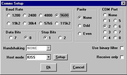
Before starting the actual setup you have to unpack the downloaded zip file and install the program according to the installion instructions. After successful installation, the individual setup of UI-View has to be done. Opening the pulldown menu "Setup" at the top of the program window you will see the 2 sub menus Comms Setup and Station Setup. For beginners, only these two sub menus matter. The other setup menus are only for advanced and special operations.
If you own a TNC, adjust the settings as above, or according your baud rate setting between computer RS-232 and TNC (not the radio!). I you don't have a TNC and you wish to use your soundcard, then you have to adjust the Host mode window to FLEXNET. More details for FLEXNET use see below.
Please read the help windows carefully which pop up during the first setup. I've heard of some difficulties using some certain TNCs.Opening the Button Setup next to the host mode window you will see further adjustment possibilities for different types of TNC equipment. Using the TNC2 you should choose the Button TF. You might have to change the switch position inside the TNC to get it running. Myself, I am using the DSP-2232, an I have adjusted it to KISS and Easy Setup PK (alike for all AEA-Products like the PK-232, PK-900 etc.). If you have made all the adjustments carefully, the TNC interface should be running now, and you should be able to receive packets or even see the station at your map. Sometimes it is necessary to restart UI-View in order to enable the COM-port (RS-232) correctly.
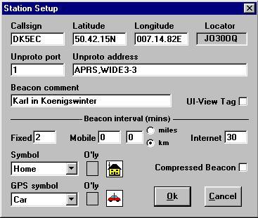
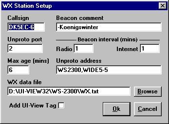
The next step would be the Station Setup. There you have to enter your callsign and your own coordinates, the rest of the inputs you leave as they are, at least for the beginning. After pressing the OK button, everything should be running ok. Better you restart UI-View another time. For the initial tests you may enter the interval 1 (minute) into the "Fixed" window, that is, you want to send a packet with your coordinates every minute. You also may initiate the packet transmission by pressing the F9 key. For normal operation as a fixed station and 24-hour operation you might adjust it to 15. If all APRS stations would use the 1 min interval, the network would soon collapse because of traffic overload. Furthermore, use the beacon comment for only essential information. Remember: the longer the packet, the smaller is the probability that other stations receive your packet. There is a rule: double the packet length equals 1/4 reception probability. The proper entry of the coordinates is very important, use exactly the same format as shown below. Most beginners oversee that, and Station Setup refuses the acceptance.
After pressing the OK button the packet will be sent out like this:
19:47:11T DK5EC>APU25J,TRACE3-3 Port=1 <UI C Len=42>:
=5042.15N/00714.82E-Karl in Koenigswinter
You may follow the transmission watching the monitor window below the map.Your map should look like this, after some time receiving packets:
At the above map you see a lot of stations using different symbols. Yo may find trucks, cars, digipeaters, fire trucks, what ever you like. One time I detected even a prison, the radio club chose the "grid" symbol, at my screen it looked like a prison cell window. Even a restroom (WC) is available. You may choose the symbol for your own station by opening the Station Setup and change the parameter "Symbol". For my fixed computer I chose "Home", for my weather station "WX" and for my bycicle the bike.
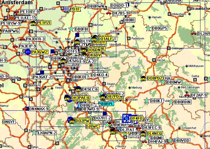
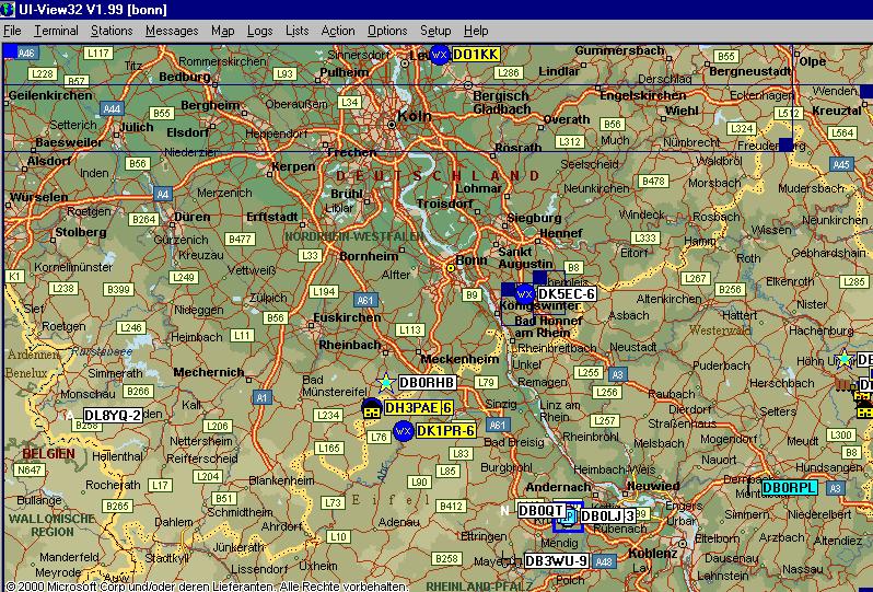
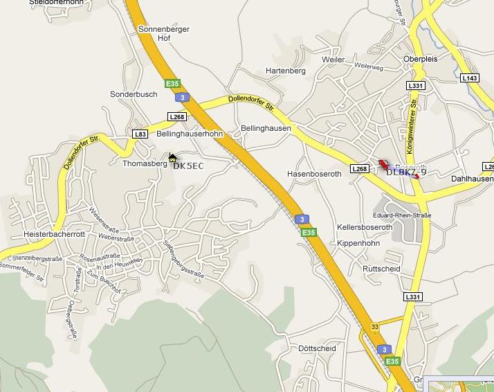
MapsAs I mentioned above there are plenty of maps available at the APRS internet sites, for Europe www.aprs.de would be recommended. Some maps came with UI-View, and for a start, the Europe map might work. But you will see that most of the stations apearing at your map will be the ones of your area. And soon the map will be filled up with so many stations of your area that you can not differentiate them anymore. Hence it is advisable to load a map of your country, state or province. The above map covers an area of about 400x400 km. But even here, especially in the more populated areas of Frankfurt or Ruhr Region, there are too many stations to keep them apart. Loading another map of the appropriate scale of my area aorund Bonn, I can clearly see all stations.
If you can't find a map of your area or your city or quarter at the internet, you may use a simple paper map (city map). You should use a scanner to make an electronic version of this map, and store it as a .jpg or. gif file. Now, you have to enter the exact coordinates which correspond to the upper left and the lower right corner of the map, into an .inf file. The above map has the file name bonn.gif, and the corresponding files with the coordinates is called bonn.inf. The content of bonn.inf is:
6.07.2E, 51.03.42N
8.0.13E, 50.16.68N
bonn
Both files have to be put into the \MAPS directory of UI-View, that is, where all other maps are deposited and found by UI-View. In the above example, the first coordinate corresponds to the area of Geilenkirchen, the second to the area of Nassau (not Bahamas, but hillbilly area of Westerwald). I scanned the paper map of my home village Koenigswinter, took my GPS receiver and went to the corresponding corners of the map by bike, measured and wrote down the coordinates. Back home I entered the coordinates into koenigswinter.inf.
In case you do not find a suiting map, you may generate any map in any scale with the help of www.aprs.fi by yourself. Display your desired map and scale in www.aprs.fi, klick on top right the arrow, then yo will get a full screen map. Move your mouse pointer into the left upper an right lower corner, and note down the coordinates. Then make a screen shot, you may cut of any undesired frames with the help of MSPaint if necessary, and store it as a .jpg-file. Now write the .inf-file as described above, entering the coordinates.
Operation with the Soundcard
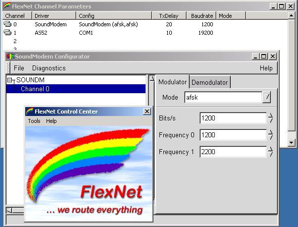
In case you do not own a TNC, or your TNC is not able to run in hostmode or KISS, then you may download a free TNC as a software package at
http://www.afthd.tu-darmstadt.de/~flexnet/
Downoad the two files flexnet32.zip and soundmodem-flex.zip, unpack and install them into the same directory, say C:\flexnet\. The following screen shot shows the necessary adjustments:
First you have to open soundmodemconfig.exe and adjust your sondmodem. it should work leaving the default settings as they are. When opening flexnet.exe you should see the soundmodem after opening the menu Tools/Parameter. In my setup you recognize two modems since I do have another modem driver for a simple hardware modem AS52 which works also with Flexnet.
Having adjusted everything you should be able to receive packets via the sound card, provided you have connected the loudspeaker or headphone output of the radio to the line or microphone input of your sound card. Check your Windows settings Volume control / Options / Properties / Recording. Transmitting packets via the sound card also works fine with the line output, but you have to make some efforts to handle the PTT function. There are many solutions for that problem available in the internet. I am using Flexnet with my notebook and the small modem AS52 when going mobile by car. The modem has the PTT function included. Going mobile/portable on foot or bike I got another solution, see details below.
Particular Properties of the APRS Protocol
The APRS protocol is based on the normal packet radio protocol AX.25 but includes some extensions for the APRS digipeater functions. Those extensions are performed by UI-View and are not part of a normal TNC. The TNC has to be operated in KISS mode. With KISS, most of the AX.25 functions of the TNC are deactivated, and the TNC is operating like a passive modem without protocol functions. The protocol intelligence is now performed by the host, that is, the UI-View software. UI-View is generating and processing the special APRS protocol features.
The position packets are sent out as so-called UI packets. UI packets are never acknowledged, they are suitable for beacons and packets which are supposed to be received by all stations simultaneously listening at this frequency. The protocol specialists call that mode broadcast or connectionless service (CLS). The contrary of this operation mode is the connection oriented service (COS) which is used for the acknowledged information exchange to a single communication partner. COS is actually the normal operationg mode in packet radio, when using the normal packet mailboxes.
In my Station Setup above I entered "APRS" into the Unproto address window as the adressed station and WIDE3-3 as digipeater. "APRS" may consist of any other letters or numbers not exceeding 6 characters. If I don't enter anything as a digipeater, then my packet will be received only by APRS stations in my neighbourhood, that is, in reach of the 2-meter signal. If I want my packet to be re-transmitted by other digipeaters or relays, I should not enter a call sing of a specific digipeater but rather the global digipeater call WIDE. All digipeaters react at the calls WIDE, TRACE or RELAY and process the received packages. My setup with WIDE3-3 triggers now the following: my station transmits the packet with the adress APRS and digipeater WIDE3-3. All digipeaters in my reach will process this package and retransmit it as APRS, WIDE3-2. More distant digipeaters, most probably out of my 2-meter reachability, will receive this digipated pakcet and retransmit as APRS,WIDE3-1. Even more distant digipeaters will retransmit the packet once more. Ohter digipeaters will also receive this packet, but will not retransmit it, because the counter is now down to WIDE3-0. Anyway, with WIDE3-3 I might cover an area of 150x150 km or more. I received packets from station using WIDE7-7 all the way from Great Britain. But dont'use WIDE7-7 except for a test purposes because, if all stations would use WIDE7-7, the channels would be hopelessly overloaded with digipeated packet waste.
The same as with the above WIDE3-3 happens with TRACE3-3, but here the digipeaters add their call signs to the address field. With that feature you can follow the route the received packet went. I observed that some digipeaters delete all previously entered digipeater call signs and put only their own call sign when retransmitting the packet. Anyway, to retransmitt 7 call signs blows up the packet length, diminishing the reception probability.
In case the range of WIDE7-7 ist not enough or you, you can book into any region of the world by using TCP/IP and the Internet. Certain digipeaters, in my area it is DB0LJ-3, allow an access from and to the internet. It would be no problem to make my position available to the New York APRS network. (Most probably nobody would be interested anayway and would not see me on the New york map.). If there is no APRS digipeater nearby you, you can reach them by using you local packet repeater and then entering the callsign of the APRS digipeater. Both I have not tried myself because I receive more than enough signals and digipeaters around the Bonn area, but I see many packets using the TCP/IP and repeater features. However, many users don't like the linking of the internet and radio APRS network because it causes additional traffic load. But to try it just for test purposes it might be fun. And it doesn't do any harm to any radio network watching the APRS traffic of New York or Tokyo or Germany choosing the corresponding repeater internet addresses, like www.db0lj.de, and having your radio switched off.
Sometimes you might recognize some funny characters in the monitor window, instead of the normal coordinates. But the stations are positioned at the right place of your map. UI-View offeres the feature to transmit the coordinates in a compressed format (see in Station Setup "compressed beacon"). The Kenwood transceivers may also transmit a compressed format called MIC-E, reducing the packet length to a minimum. Above I mentioned already, reducing the packet length by half increases the reception probability 4 times.
A Weather Station using APRS
The above described features you get for free provided you own the basic equipment as a radio amateur or listener. Last time I managed to divert € 170.- from my paycheck, and I bought myself a weather station WS 2300. Most big electronic stores sell those things for about € 200.-, I bought mine via Ebay for a little bit less.
The WS 2300 features about everything you need, that is, sensors for temperature, air pressure, rain and wind, which habe to mounted outside the house. You may get detailled information of my new toy at http://www.heavyweather.info/.
This gadget also features a RS-232 interface and software, enabling a connection to UI-View. However, you have to consider certain facts, it took some time to overcome all the problems. What do you need to be a weatherman for the APRS network? Here is the answer (at least how I did it):
- Weather Station WS 2300
- Software-Update for PC HeavyWeather 2.0 beta, download at www.heavyweather.info
- Software UI-View32, Version 1.84 or above
- Software UI-Weather, download at www.apritch.myby.co.uk/uiweather.htm
Attention: the documentation is an additional file
- Software HeavyWeatherPublisher, if you wish to send it to corresponding weather servers into the internet, at www.heavyweather.info
Alle the software is freeware, except UI-View32. Unfortunately it does not work with the free 16bit-Version of UI-View. The whole package runs as follows: the software Heavyweather loads the weather data from the WS 2300 via the COM-port and saves them in the file currdat.lst. The software UI-Weather converts these data in a format suitable for UI-View32 and saves the converted data into the file wx.txt. Now you have to enter the the corresponding directories and file names in UI-View32 Setup/WX-Station Setup und UI-Weather in order to make them known to each other. My adjustements are as follows:
_
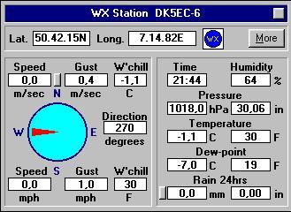
After having entered the filenames and directories correctly, the weather data are now being sent into the APRS network, depending of the WX-Station Setup-Timer Beacon Interval/ Radio. The weather station appear at the map as a blue dot with the letters WX. By clicking at it a window opens with all the weather data of this particular station.
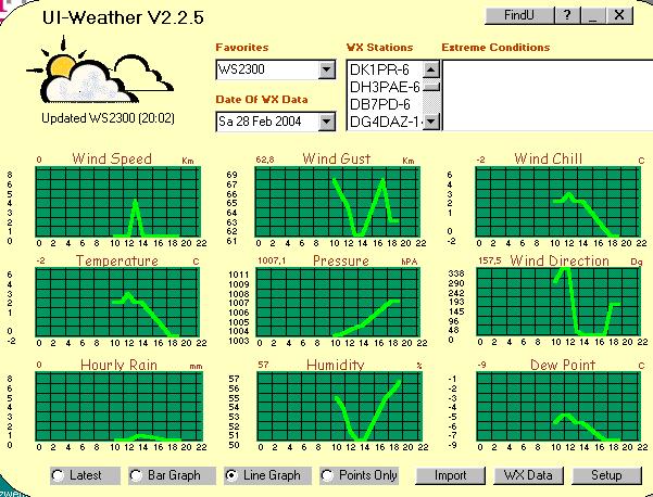
Below you see the screen shot of UI-Weather which links the software of the WS 2300 to UI-View32. This software also saves all the received data of all the weather stations and can display these data in a diagram covering a 24h period. Also the graphs of the earlier days may be displayed. And that is all freeware!
APRS as mobile and portabel station
Whatever James Bond can do, (DK) 005 (EC) has been doing it now for several months, and all that without the support of MI5. At least concerning the use of location tracing tools. As you can see in the above maps, some of the stations are presented as cars, that is, mobile stations. Clicking at one of these mobile symbols another popup window appears with some information of the current speed and direction of this car. The same thing goes for walkers and bike riders. As a mobile station, however, you have to invest a little bit in special hardware. Definitely, you will need a GPS receiver, you may buy this for about € 100 (GPS Mouse). You also need a mobile TNC which may be part of the following equipment:
- Notebook with Flexnet
- PAD with Flexnet
- transceiver with a built-in TNC function
- TinyTrack (microcontroller)The first two types are fully equipped computers which may be loaded with the suitable APRS software or sound card TNC. You have to connect the GPS receiver to the notebook or PDA, to configure the APRS software, do the necessary cabling for the audio and PTT connection between transceiver and the computer, and it should work. Unfortunately the Notebooks or PDAs offer only 1 RS-232 (COM-port). That is allright if you use Flexnet and the sound card, this way the RS-232 is available for the GPS connection. However, if you use a TNC or modem, they have to be connected to this single RS-232, too. There are two solutions for that problem: Either you use a USB/RS-232 converter cable for your GPS, or you build yourself a small adapter, consisting out of some plugs and diodes enabling the simultaneous use of a single RS-232 connector for the TNC/modem and the GPS. The latter one is described in the UI-VIEW help functions or manual.
The fasted method to get started with mobile or portable APRS operation would be the purchase of a transceiver with a built-in TNC function, like the Kenwood TM-D7000 for car use or the handheld TH-D7 for portable operation. However, that would be an additional investment of about € 500 - 700.-. You will find plenty of information about these transceivers in the internet at the APRS sites, how to connect them with the GPS receiver, the setup etc..
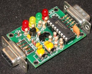
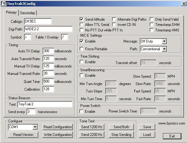
I you don't have that kind of money laying aorund you can do the same thing for € 40 or less, provided you have already a handheld or mobile transceiver. The less expensive solution would be the TinyTrack, a small module consisting of a micro-controller, some LEDs and other passive parts, about the size of matchbox. This module converts the NMEA signals of the GPS receiver into APRS data and sends them as true AX.25 audio signals, including PTT function, to your transceiver or handy. You just connect a cable between the TinyTrack and the microphone input of your transceiver. The module has to be configured by connecting it to the RS-232 of your home computer, entering your call sign and beacon text. You may change between two configuration setting with a switch. I use different settings when using the car or my bike. You may only send APRS packets with this module and can not receive. But not having a display available anyway while riding the bike this restriction is allright with me.
I fought out a battle with myself deciding between the transceiver with the built-in TNC feature or the TinyTrack. Finally, considering the price of € 500.- and owning already a duoband handheld (which I harldy use) I decided in favour of the TinyTrack. I bought my TinyTrack via the internet for about $ 30 as a kit, additionally shipping costs of $ 9.-. You may get it also in the big ham radio stores, but for double the price, at least here in Europe. Don't be afraid assembling the module yourself, I was able to do it in spite of my eyes being more then 59 years old, the kit absolutely doesn't contain any SMD parts.
Look up for more information at http://www.byonics.com/.
The TinyTrack looks like this, and has to be configured with the included configuration program.
Once in a while I take my TinyTrack and GPS receiver along for a bike ride. The whole world now can trace my route, riding along the Seven-Mountain Street, take a turn to the right into the Meadows Street. In case the whole world is not interested in my bike ride, I can trace the whole ride at my home computer after coming home. In order to do that I have to click at my mobile symbol and set it to "Trace" and "Logging", that is, before I start the bike ride. Coming back home I now can replay my bike ride with different time scales loading my home made area map. It is a lot of fun to demonstrate this feature at ham radio meetings, Jamboree-on-the-Air and other occasions.
APRS via space stations and satellites
APRS may be operated also via the International Space Station (ISS), the APRS satellite NO-44 or PACSAT AO-16. In the olden times I have seen many APRS stations using the good old MIR. Since space communication is one of my other hobbies, I am equipped rather well doing that type of communication. I you are interested in my space activities, you may have a look at my AMSAT publicateion "Amateur Radio via Satellites and Space Stations". Actually, an amateur radio station equipped with the usual simple transceivers and antennas may participate in space communications. There are quite sophisticated satellite tracking programs available showing the exact times of the passes of the space objects in excellent graphical presentation, most of them as freeware. I am using PCSAT32 myself which, besides the graphical display with world an area maps, also controls my antenna rotor system and my transceiver's frequencies. Further details you will find at the above AMSAT page.
Teh signals of the ISS and NO-44 are rather strong so that I can work them with a good vertical antenna. That goes for mobile stations alike. Myself I have not managed it with my handheld, it can do only 2 W power, but other handheld owners have done it. However, the ISS and the satellites operate as normal digipeaters without the features of WIDE and TRACE, and you have to enter the specific call sign of the space object, that is, RS0ISS-3 (for ISS), PCSAT-1 for the NO-44 and PACSAT-1 for the AO-16. Further restrictions exist concerning operating times. The NO-44 seems to have trouble with the batteries, and you only can work it daytime when there is enough sunligt available for the sun sails for this bird. The ISS is not always on the air with its packet transceiver. The most reliable satellite is AO-16, but you might need additional equipment for it. It transmits on 437 MHz and receives at 145 MHz, you will need either 2 transceivers or a satellite transceiver like the ICOM 821. Furthermore the AO-16 ist transmitting in PSK modulation, whereas normal modems only do FSK modulation. Because of that, normally I am the only operator on AO-16. Anyway, its always a nice feeling watching the ISS re-transmitting my position so that 1000 or more European stations can receive it.
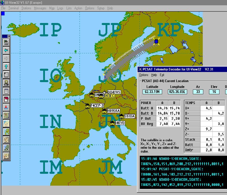
At the picture below you can see the UI-VIEW screen shot while monitoring the NO-44. There is a freeware software addition for UI-View32 called pcsattlm.exe (download www.ui-view.com) showing the actual orbit and some telemetry. I took that screen shot a few month ago when the batteries were still ok, nowadays the parameters Batt A and Batt B are below zero.
APRS Infomation from DK5EC live via Internet
The program UI.-View has some other nice features, especially for those having a DSL connection into the internet. Via File/Internet Time Client you can get the precise time, your system clock is automatically set. I need precise system time especially for my satellite activities.
A great feature of UI-View is the built-in HTTP server function. When activating File/WebServer, you have a HTTP server running on port 80, including an APRS web page. you may have a look at it by typing the adress http://localhost in your internet browser. You will see a table of all received APRS stations in aphabetical order. Clicking at on of the stations you get more detailled information including 3 maps of different scales showing your position. At my page dk5ec.dyndns.org you can even see a satellite picture of my QTH. The maps and the satellite picture is actually not present at my computer at home, it is rather a link to a map and satellite picture provider. The default links of UI-View to those maps do not work properly at my page, but I have chnged them to good ones which work great. In case you have similar problems, I will send these links to you.Well, it would be nice if other OMs could get to your new HTTP server and see all the sations which you presently receive via VHF. Firstly, they can't because they don't know your present dynamic IP adress. No problem, they don't need it, because you can assign your dynamic IP adress to a firm HTTP adress, that is, internet adress. You can enter a fixed internet adress at the DNS server dyndns.org, I did it as dk5ec.dyndns.org, and all for free. I works like this: if your computer is connected via DSL into the net, a short message to this DNS server is sent, telling him which IP adress you presently own. The DNS server assigns this IP adress to your domain callsign.dyndns.org, and anybody in the world can reach you via this internet adress. To make this automatism work you have to adjust your router, or you can download a small programm from dyndns.org.
You also can sent all the positions your received via VHF to an APRS server in the internet. Then your information is distributed worldwide, and anybody can follow up the active APRS stations in your area. My friend Rudolf, HS0ZER, feeds the western Germany area VHF APRS net with his position, and I receive it here via VHF, Of course I can not see him on my Germany map, I do not have any map from Thailand.
At my satellite page I have described how I feed telemetry and APRS data of the ISS/PCSAT2, which I received on 70 cm, into the internet to an APRS Server, and finally to the US Naval Academy. The students there built this PCSAT2 module which is now attached at the the outside wall of the ISS, and they are happy to receive PCSAT2 data from all over the world.APRS mit Google Earth und aprs.fi
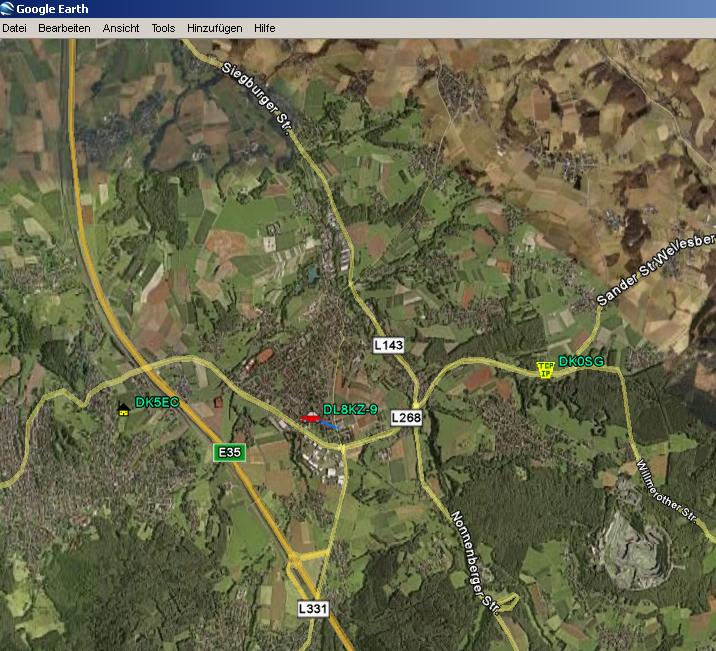
Google Earth also can display most of the APRS Stations. Many hams also feed the APRS positions received via radio into the internet, see UI-View menu /Setup/APRS Server Setup. First, you should download the plug-in Google Earth KML from the page aprs.fi, see text window on the right. Then execute the file aprs.kml. Google Earth will open, and you should see "APRS, all targets in view" in the left text or menu window. All APRS stations of the selected region will be displayed. The mobil stations will be even dsiplayed with their track. Very impressing are airplanes and baloons with APRS on board, they are displayed even with their altitude track in a 3-dimensional manner.
When going to www.aprs.fi, you may enter the callsign of any APRS station. If the station is on the road the site starts searching for this particular station and will display it at the corresponding map enviroment. When Daddy is again on a business trip, Mum can follow his track at the computer at home (if Daddy wishes to).When I don't reach Heinz, DD9KA, at his home on our club frequency, I will search for him via aprs.fi. And sometimes I will find him parking in front of the supermarket, sometimes on a trip to Paris.
That's it!
Well, now I'm coming o the end of my explanations about APRS with many of its side features. There are a lot more possibilities, but time restricting my activities. Just start with the things I explained at the beginning, and you will have a lot of fun. I hope to see you on my screen very soon!
73,
Karl in Koenigswinter-ThomasbergDK5EC@DB0MKA